Retired boomer, out to walk my dogs, ride my bike, and hike the forest paths around Monroe County Indiana. Recently found ADHD runs in my family, and apparently gallops in me…
On Saturday, Jojo and I went for a bike ride east of Bloomington, and while hiking in the Yellowwood forest found the motherload of bluebells (Mertensia virginica). Two weeks before we had ridden to Woodall Road where we had found them last year, but no luck, and a lot of hill climbing resulted. But this cool clear spring day we encountered a side valley that eventually rises to Scarce o’ Fat ridge.
All along the forested valley floor the bluebells were only plants visible, with an occasional buckeye sprout rising above the carpet of blue flowers and magenta buds. There was a dry branch running through the middle, and we walked up it a few hundred yards and sat on a log to admire the etheric glow of the bluebells. Right next to us I discovered a rare plant which did not turn blue once it flowered. (The bluebell buds are magenta when they appear, then as the flowers grow out of the buds, they morph to the a vibrant deep blue.) The pink bluebell seemed to be pretty rare, of the tens of thousands of flowers in the valley we saw only 2 pinks, and they were close together.
I’ve heard from others that this has been a good year for bluebells, they certainly did like this spring. They are perennials, but also spread from seed that is not easily dispersed. This means that they take over whole areas of a forested flood plain; here they were even beginning to climb the hillside, not their normal habitat.
We walked up the dry branch into the Valley of the Bluebells | Flowers 2009
Bluebells morph from Magenta to Blue | Flowers 2009
We took off a bit late at 3 pm, and headed out for Bottom Road. We usually ride through Cascades Park, now that the speed limit is 20 mph, it feels really safe for bikes. The climb past the monastery is short enough that you feel good and warmed up by the time you crest the hill, yet not worn out. We rode out Kinser Pike to Bottom Road, and headed north. Its about five miles of “flat” riding up to the intersection of Woodall Road. We rode Woodall for a while, then took a right on Woodland Road, which rises out of the valley, and then took Barr Road again dropped into the Bean Blossom valley, and to our suprise we found a dry waterfall with a large pool below.
It was quite interesting how the water was totally contained by large rocks, even though it was dry uphill and downhill from the site. My camera had a finger smudge, so my pictures aren’t that great, but I posted them anyhow.
Both Barr and Woodland Roads end on Mt. Tabor, which is fast busy road. We rode a short distance to Cowden Rd, which runs east for a mile or so, a quiet residential ridgetop ride. We debated taking Union Valley to Maple Grove West, but they are both fast busy roads, so chose to take the longer Delap Road loop to the beginning of Maple Grove Rd North. (Yes there are 2 Maple Grove Roads, and they intersect at right angles!)
Delap runs the ridge for a while and offers some great views of the Bean Blossom valley. We passed a farm with peacocks and llamas, very scenic in the early evening sunlight. Where Delap drops into the valley we found a cascade/waterfall, probably spring fed, as it was running strong. We stopped to explore and found that there were two parts, dropping about 15 feet. This video should give you an idea of what if was like:
Maple Grove goes generally south, crosses the east/west Maple Grove, and then ends on Arlington Road. We rode up and up a long climb after 30 miles. Even though it is not a steep grade, Arlington Rd. rises over 150 feet (701-855 ft) as it climbs past Hoadley Quarry and over SR 37 and then the Bypass. We were tired, but happy to have been out over four hours and found new places to enjoy.
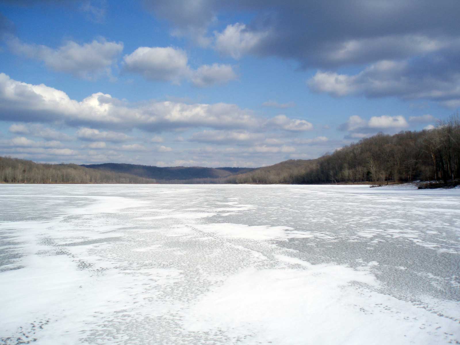
Wahoo! Another year of ice riding on Lake Monroe (and Griffy), you know, I sometimes worry the ice will not form (like in 2007). But this year the ice has been over 4 inches thick for over three weeks, and had many different faces. And yes, I wear my sandals (and 2-3 pairs of socks) on the ice. I have shoes that I use only when there is deep snow.
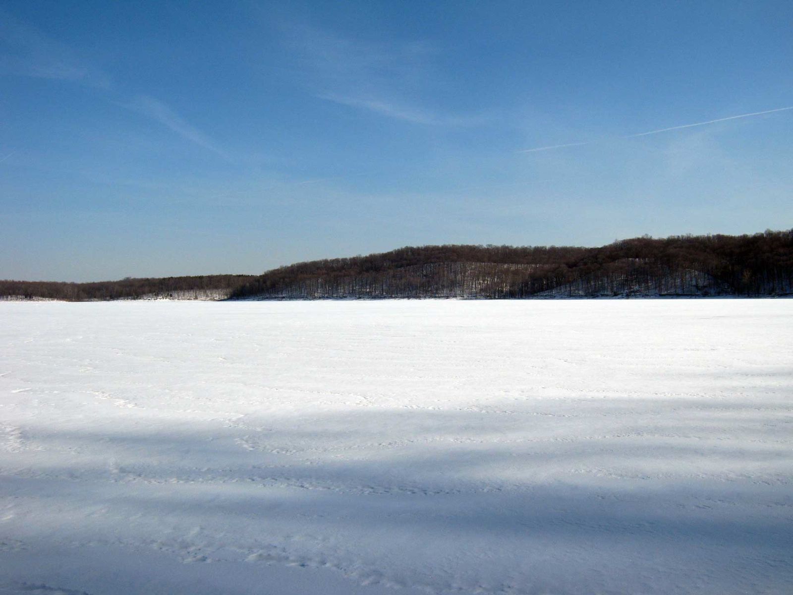
Lake Monroe ice
I took 2 vacation days from work to ride on the lakes, and it could not have gone better. I know most folks find it hard to believe, but these days were really fun. I logged about 75 miles of the flattest riding you can do in southern Indiana, and never once came close to any real danger. During my 20 hours on the ice I saw 5 fisherman, 2 campers, 3 coyotes, 3 hawks, 2 bald eagles, and 1 great blue heron. We had no problem sharing the lake.
The lake seems much smaller when you can ride rather than rowing, I’ve been end to end on my bike.
Snow can be a help in winter riding. Up to 2 inches will help hold the bike upright, although it does slow you down (a better workout?) More than 2 inches is a challenge.
Snow can be slippery. The only time I fell was riding on thin snow over rough ice.
White ice generally has better traction than clear ice, but is often bumpier.
Black (clear, green or blue) ice is ridable, even though it appears smooth, there it plenty of traction (as long as there in not a thin layer of water or snow on top.)
Braking is a challenge, it is better to stop pedaling and put your feet down.
Make wide turns only, or find yourself on the ice.
Use low torque, ie don’t press hard on the pedals, or you may peel out and meet the ice.
Cracks that have water one side or the other are scary, even though I know there is ice underneath the water. But who wants wet feet in January? I ride parallel till I find safe place to cross, which may be at the shoreline.
There are coyotes, eagles, geese, and great blue herons at the lake in the winter.
The Middle and South Forks of Salt Creek are frozen highways to Elkinsville and Maumee
A cup of tea is quite refreshing when on the ice.
The ice grumbling under your feet and pinging across the lake is a good thing, it is the sound of ice being made.
I mapped out a couple of my Lake Monroe routes after the fact, just to see how far I’ve traveled, and to fix in my mind where my photos were taken. It does help to have a map on the lake, on my first ride to Elkensville, I somehow started up Axom Branch, rather than riding north and then east.
If you’ve ridden the Hilly Hundred when it went east, the killer climb comes right after lunch. After riding the gentle valley north out of Nashville, you run smack dab into Bear Wallow Hill. It has has the largest rise of the climbs in our region, starting at 692′ in the valley to 1010′ on the ridgetop, a climb of 318 feet.
It is .75 miles long and using my Mitch’s Hill Toughness Quotient, it is a difficult hill at 424. However, its length and rise are more than any other hill I’ve found, and so this hill is tougher than the quotient would indicate. [318/.75=424].
In comparison, TC Steele has a higher quotient at 474 MHTQ, but it’s a third shorter at .42 miles and rises only 200 feet. Bean Blossom Hill to the ridgetop is a long ride, 1.25 miles, and it rises 293 feet, but the math works out to a measly 227 MHTQ. So I would say Bear Wallow Hill is much tougher than Bean Blossom HIll, and probably harder to climb overall than TC Steele. I’ve climbed them both on my recumbent, so I know they are in the same neighborhood. But no doubt Bear Wallow is more of a killer, especially in warm weather. It just keeps going and going and going. But by pure numbers, Miller and Boltinghouse Roads are still the toughest paved Hoosier Hills, and McGowen is still the toughest by far.
On the way out of Pine Grove, I watched a great blue heron take off from shore and cross the lake, I am sure he was hungry as all of Lake Monroe was frozen. I heard a few woodpeckers calling as I rode over the ice towards Elkinsville, and I found some tracks in the snow cover.. But it was not till I was returning westward, when I spotted three coyotes running across the ice. They stopped and watched me for a while as I watched them, but when I started moving, they took off, one split off parallel to me along the ice, the other two started running towards the south shore.
Then as I came around the last point before heading for Pine Grove ramp, I saw a full grown bald eagle take off heading east, he/she had been standing on the shoreline, no doubt wondering when the ice would melt.
Though not exactly an easy task, it’s not impossible, and can be fun. I ride more slowly in the winter, the wind chill at 15 mph can be brutal when it’s 20 degrees. So I don’t worry about being aerodynamics, I just bundle up in my winter coat and ride at 10 mph. There is great beauty in the bare winter landscapes, and the birds that winter here are easy to see with no leaves on the trees. With a light dusting of snow the hillsides glow in the early sunsets as the geese fly overhead.
The first week of January was quite warm, in the 50’s though cloudy, making for good riding. I’ve been exploring the east side of the county lately, riding a variety of loops on McGowen, Friendship, Duke, Kerr Creek, and Lampkin’s Ridge Roads. In years past, I’ve worked the loops to the south, riding to the lake via Stipp, Moores Creek, Ramp Creek, and Pine Grove Roads, and it is always fun to be by the water. But heading east, the Wildlife Nesting Area and the forests are the draw. Except during the fall hunting season, the Salt Creek valley north of the lake is empty (with the exception of birdwatchers and the occasional DNR employee) of humans.
Another reason to bike or walk (besides its being fun and healthful!)
Here are some interesting numbers listing the calories burned per mile via various modes of transportation. A bike offers mechanical advantage that is unbeatable, but if one factors in the environmental cost of creating a bike versus a couple pair of shoes, perhaps the two are about even.
Calories burned directly correlates to carbon dioxide release, either from our breath while walking or biking, or from the tailpipe emissions from our vehicles. So it looks like biking or walking are nearly an order of magnitude better riding than oil burning vehicles, especially cars.
This was to be any easy road trip, about 25 miles, out Kerr Creek to Gettys Creek and Mt. Gilead. We doglegged over to Robinson Rd, and took Nerhtz. We climbed the little hill, and then my chain broke (again). The guys at Bike Garage had fixed the chain and ordered a new one, so I knew I was taking a chance. Jojo was able to grab the back of my seat, and pulled me along the ridgetop.
I coasted downhill, and we turned on Earl Young so we could stop and attempt a fix at Alan’s farm in the valley. It was a cold day and we were hoping to warm up by the wood stove before working with the cold metal chain, but he was not home. We sheltered in the barn, and miracle of miracles, I had my chain tool with me (I had carried it for years with ever using it!)
This was a tough ride, kind of cool, which was fine till my chain broke, and we had to fix it as the snow fell. Jojo was with me and we worked for a half hour to get it “fixed”. Truth is I missed threading the 10 foot chain through the front derailleurs, so I had only my highest gear. Even so, I made it up Firehouse Hill and back to town.
I know that I might break down at any time, that’s part of the adventure. It is good to know I can fix things and get back some of those times. I’ve had to call Eileen for a pickup only 2 or 3 times in the past 5 years, twice at dusk, once because I had no tubes or repair kit.
So now in my pannier I have 2 extra tubes, a small pliers, a tube patch kit, tire tool, a pump, and a set of hex head wrenches. In winter I often carry a thermos of hot tea, food, extra socks, a bird book, and a poncho. So I am usually more than prepared, and even though I carry extra weight, I don’t find it a burden. I may go slower, but I can get farther and be more comfortable during the journey, and this I like!
On most weekends I try to ride for four hours or more, anywhere from 30-50 miles is great, but during the week, I sometimes want to ride after work, and so 15-20 miles is just about right.
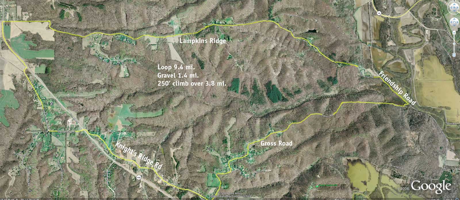
For many years my favorite short loop rides have been Kerr Creek-Mt Gilead and Stipp-Schwartz Ridge (named for the hills on the route). But since I have learned that my bike can handle gravel roads with no problem, I decided to find a new route, and here it is:
Starting at Lampkins Ridge and 446 (which is about 4.75 miles from Sample Gates), the loop goes down Knights Ridge to Gross Road, which runs along a ridge and into the forest. The last mile is gravel and drops into the Salt Creek valley ending at Friendship Rd. It’s then a short ride north to Lampkins Ridge Road, which climbs about 250 feet over 3.8 miles, but only the beginning is really steep. The loop is 9.4 miles, and with the ride from home and back, it is just under 20 miles.
There are a couple of ways to get to SR 446, I used Covenanter on the way out, and the Polly Grimshaw trail on the way back. They are about the same distance, but the trail feels safer on the way back after dark.
The sun was still up as I rode along Knight’s Ridge Rd, and the sky was blue. But as I turned onto Gross Road, the sun was setting, and the shadows were lenthening. Gross Road is narrow but well paved until it turns to gravel as it enters the uninhabited forest. I stopped in the forest to have a drink and listen to the birds and look for mushrooms.
After about 5 minutes, the only car I had seen so far came to a stop and asked if I was heading into the forest on my bike, I had pulled it about 20 feet off the road. I said no, I was heading down to the valley. He said ok, and left, but I realized he was going to warn me about hunting season, and there are people with deadly intent all over the state forest land. I am not so afraid of the bow hunters, they all seem sober, and have to get pretty close to shoot. But it is now firearms season, and I’ve already run into several drunk guys with guns looking for deer. The firearms season for deer runs November 15-30, although muzzleloaders are allowed through December 21. I plan on staying on the roads till next year, that’s for sure. The bowhunters are there only in October and December, so by January the woods are quiet once again.
Salt Creek runs next to Friendship Road, and as I walked down to the banks, I heard a loud mechanical sound. I supposed that it was the farmer on the other side of the creek running his combine, but as I got closer, I saw that was not so. A large tractor was backed up to the creek, and was running a pump to bring water up over the levee and into the fields. Later in the week I noticed the whole field was flooded, and I realized the DNR had done this to fill one of the lagoons that had dried up in the recent dry spell. I’ve ridden on the dikes farther south during the dry season, but I did not know the ponds were filled this far north.
I started up the Lampkins Ridge hill, and was just near the end of the first steep climb when my chain broke. I didn’t have a link tool with me (I do now!), and it was dark anyhow. I figured I could walk the bike and coast the downhills, and was about a mile into a 8 mile trek when a van stopped to see how I was doing, this was only the second car that had passed me since I turned onto Gross Rd. The driver was Michael Glasgow, who is a mechanic for DeCycles and a rider himself. He put my bike onto his roof rack, then he took me home, what good luck! Thanks to Michael, and to all those who recognize someone in need and are happy to help.
I took the same route late Saturday, and made it the whole way with no problem. When I got to Friendship Road and took a right to the south, it was still light, but within half a mile I found a hunter’s camp along the roadside. The woodsmoke smelled good in the cool evening air, but I decided not to drop in on them, and headed back to Lampkin’s Ridge and home. All in all I like this ride, 5 miles to the woods, then 10 through the back country, and 5 back home, not bad.
This Sunday the time changed, I got up “late”, but still got an early start. I wanted to see as much forest color as possible, and I headed for Shilo Road, first riding down newly paved Kerr Creek Road. It has smooth blacktop all along its 3 mile length, and I was able to ride down with no brakes. It is not that big a hill, falling about 100 feet on the main hill. (Stipp Road, my favorite downlhill, in contrast drops 180 feet, and I easily hit 40 mph on it.)
I turned left on Gettys Creek Road, and then took Mt. Gilead northwest to SR 46 near Unionville, and rode over to Tunnel Road. Although this route is longer than riding out 10th St. (SR 45), plus a good climb, the valley is really sweet and quiet with colorful ridges on either side. I took Tunnel to Shilo Rd., which to my surprise, is also newly paved! This is a ridge ride of 3.8 miles through the forests that overlook the Bean Blossom valley. Shilo Rd. drops into the valley, crosses the Bean Blossom, and ends on Anderson Road, which I took to Low Gap Road.
OLYMPUS DIGITAL CAMERA
Low Gap runs north-south through the Morgan-Monroe Forest, rising out of the Bean Blossom valley and up over the ridge and then back down into the Indian Creek watershed southeast of Martinsville. As I passed the parking lot next to one of the forest trails, I saw a group of hikers, and a fully camouflaged bow hunter. At the top of the ridge, I took Orcutt Road to the west, riding “Safety Zone”, where hunting is disallowed. I love the cool beauty of this ridge, and I sometimes ride several miles east through the woods to Bear Wallow Road. But with bow hunting season in full swing, I decided to play it safe and stay on the paved roads as much as possible.
Gravel 180
On Forest Road, I found the Major Taylor team riding training runs along the ridge. I’ve seen other teams up here, as the five miles from Old 37 to Rosenbaum Road is well paved and level, there are few roads in the county that can say that training. I got inspired and rode back and forth once, admiring the yellow light shining through the trees, the incredibly blue sky, and clean cool air.
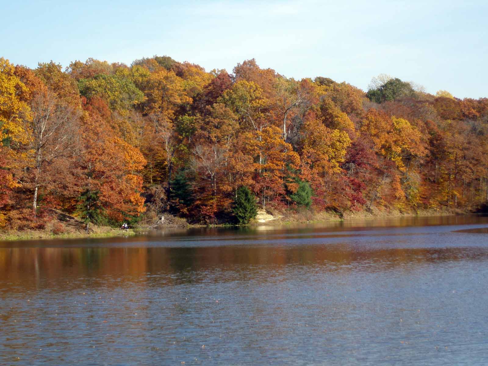
Bryant’s Creek Lake
Eventually I headed home, though I stopped at Bryant’s Creek Lake to take in the view, then again at Melton’s Orchard, it was quite the scene, their parking lot was full of both cars and bikes stopping by for cider and apples, they have a great selection, I will be back!
Musgrave Orchard
Old 37 is closed just south of Hindustan (where the orchard is), they are repairing a bridge, so while bikes can get through, cars can not, and it was quiet riding most of the way south to Dolan. I rode up Firehouse hill, then cut over on Bethel Lane to Headly Rd and Griffy Lake. Bethel Lane seems very dangerous to me, there are so many blind hills and the cars travel well above the speed limit of 35 mph. But I made it once more, and rolled on down to the lake for a short walk in the woods with Eileen.
I was surprised to learn (by plotting my course on Google Earth) that I had covered at least 50 miles (back and forth on the ridge pushed me past 50), and I felt fine (tired, but fine) as I climbed up Headly Rd. hill and back home. Thanks to good advice from Sue Aquila, I had kept my blood sugar levels fairly steady by eating regularly, and I even had some good salty corn chips at lunch, and I did not bonk even at the end.
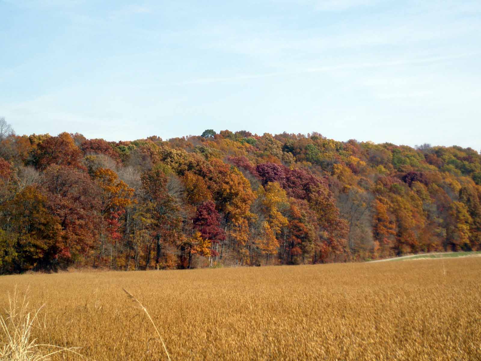
Nature Notes: The leaves are fully turned now, and although yellow predominates, the red, orange and brown leaves are now especially visible. On Getty’s Creek I stopped when I saw a really large pileated woodpecker fly in front of me and call. I looked up and found a hornet’s nest in the tree I was under. I pulled out my camera to take a picture, and heard the unmistakable call of a red tailed hawk as it launched itself from nearby tree and flew out over the valley. Very few flowers and bees were evident, even the goldenrod is gone, but I did find some late chicory and a few asters along the roadside.


 On the way out of Pine Grove, I watched a great blue heron take off from shore and cross the lake, I am sure he was hungry as all of Lake Monroe was frozen. I heard a few woodpeckers calling as I rode over the ice towards Elkinsville, and I found some tracks in the snow cover.. But it was not till I was returning westward, when I spotted three coyotes running across the ice. They stopped and watched me for a while as I watched them, but when I started moving, they took off, one split off parallel to me along the ice, the other two started running towards the south shore.